National Security
What the satellite images show, and what they do not
Open-source imagery shows a tug and barge together and an apparent slick south of Tobago. It identifies the vessels more firmly than the official account has. It does not yet say who sent them or why.
Investigation file · February 2024
Follow the evidence, not the name painted on the hull
This visual reconstruction follows Robinson's reporting: the contradiction he identified, the satellite evidence he published, the questions he put directly to TankerTrackers, the claims he withheld and the findings later confirmed.
Editorial reconstruction from public AIS reporting and satellite analysis. It is not satellite photography and does not claim a complete track.
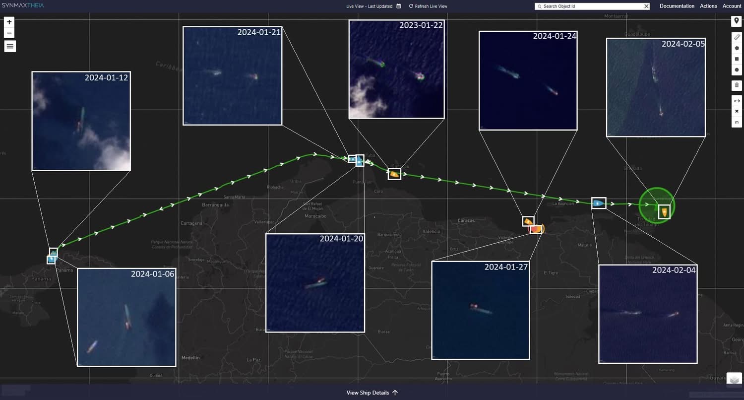
Colón to the Venezuelan coast
Bellingcat reconstructed the tow from public tracking and satellite material.
Seen in Pozuelo Bay
TankerTrackers told Robinson it had observed the vessel there for about a week or more.
Leak visible south of Tobago
Bellingcat reported satellite evidence of leaking from about 3 February.
The intended destination
A track is not a charter, bill of lading or port instruction.
Contemporaneous satellite record
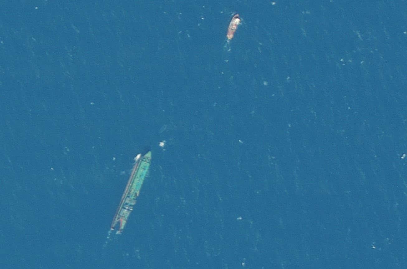
Evidence note: these images are reproduced from the owner-supplied contemporaneous reporting record. Labels and route lines are annotations; each claim is tested against the separate source record.
Reporting sequence
Updated 2 October 2026 with interactive graphics and linked documentation. Original publication date retained.
The clearest evidence about the Gulfstream so far has come from space, not from the State.
Satellite images circulating among open-source researchers, which I have been publishing and examining, show a tug and a barge travelling together in the days before the capsizing, and what appears to be an oil slick in the water south of Tobago.1
The images are not decorative illustrations. Each frame has to be read with its date, coordinates, sensor limits and the separate maritime record used to associate a small shape at sea with a particular vessel combination.
Who found what
Bellingcat, the investigative group, identified the overturned vessel on 14 February as most likely an unpowered barge named Gulfstream, half of an articulated tug-and-barge unit. Such barges often carry no IMO number of their own, which explains why divers found a name on the hull but no number.2
TankerTrackers.com, which monitors oil shipments, reported that the barge had been seen in Pozuelo Bay, Venezuela, in late January, and that it may have been carrying up to 35,000 barrels of fuel oil.1
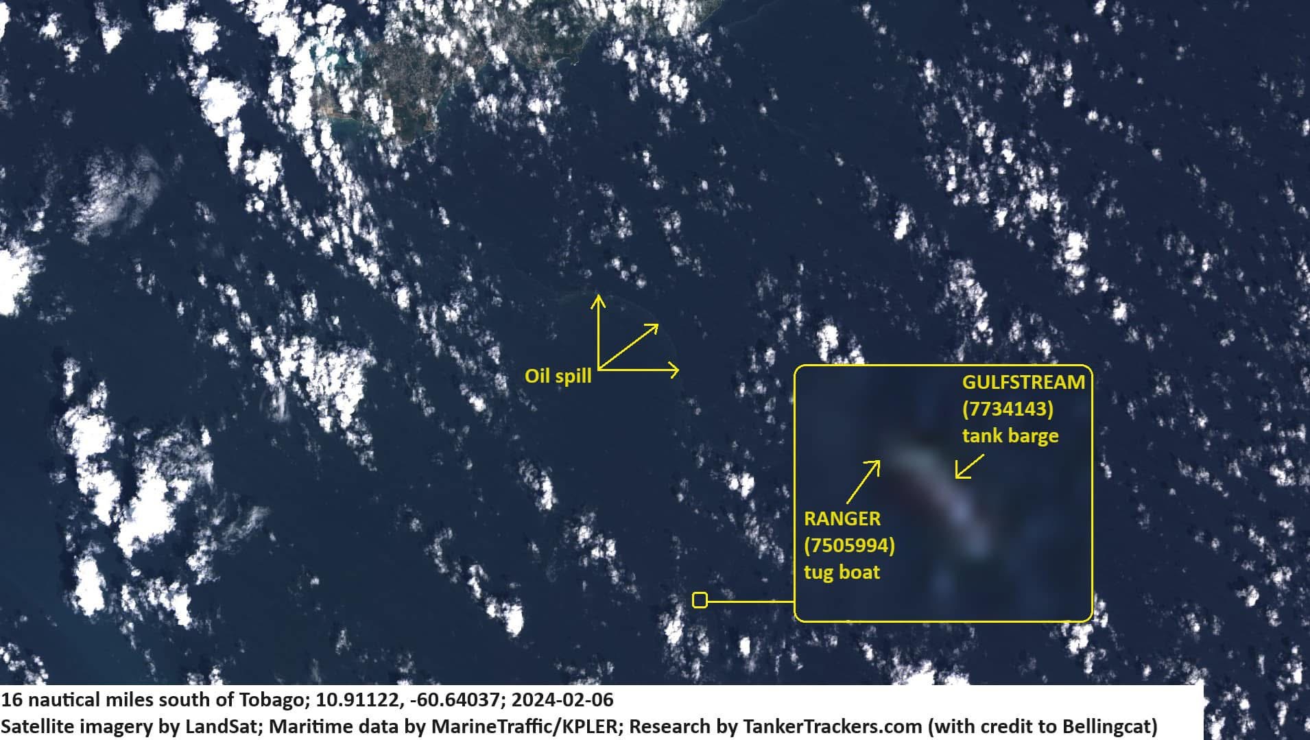
The supplied Landsat image dated 6 February is annotated with the Gulfstream barge, the tug associated in the research with IMO 7505994, and an apparent slick about 16 nautical miles south of Tobago. Those labels are an analytical overlay. The underlying image records reflected light; the identification comes from matching position, timing, shape and the wider voyage sequence.1
What the imagery establishes
It establishes that a specific tug and a specific barge were moving together, and that the pairing matches the vessel found at Cove. It establishes that oil was in the water before the barge came to rest on the reef. That is more than the official account had offered by Friday.
The multi-date sequence adds another layer. Frames associated with the crossing place the unit from Panama through the southern Caribbean and along the Venezuelan coast. Read beside the reported AIS record, they allow observations during a period when the tug was not continuously visible on public tracking services.
How the identification is tested
No single low-resolution frame carries the answer. The test is cumulative: the relative size and alignment of tug and barge; their repeated appearance as a pair; the time between observed positions; the Ministry's naming of the Solo Creed; and the match between the damaged Gulfstream hull and the unpowered barge identified by Bellingcat.2
That method also guards against a common error. A dot at sea cannot be assigned a name merely because a database shows a vessel nearby. The timestamp, location, dimensions and voyage continuity have to agree.
What it does not establish
A satellite image shows a shape and a position at a moment. It does not show a cargo manifest, a charter party or an owner. It cannot say whether the barge was loaded in Venezuela or simply passed through. It cannot say where the tow was finally headed. Those answers need documents, and the people who hold them have not produced them.
Nor can the absence of an AIS transmission prove intent. Equipment failure, coverage and deliberate switching-off are different explanations. The evidence here supports a gap in the public signal and continued physical movement; the reason for that gap remains a separate question.
The public record against the official account
The official account supplied names and a stated voyage toward Guyana. The imagery supplied a route with a material Venezuela chapter. The two are not necessarily mutually exclusive, but the second makes the first incomplete. Any adequate official chronology must explain the Aruba call, the Venezuelan observations, Pozuelo Bay and the loss of the barge.
What I am checking next
The tug's movements before and after the barge was lost; the period in which its transponder was off; the cargo; and the vessel's earlier names. Each requires a different record: satellite observations for physical presence, AIS history for broadcasts, terminal and shipping documents for cargo, and flag-state or registry material for identity.
Citations & source document
- [1]Pearce Robinson — satellite and open-source material, 16 February 2024Satellite and open-source materialImagery of the tug/barge combination and apparent slick; TankerTrackers attribution.
- [2]Bellingcat — Identifying the mystery vessel, 14 February 2024Satellite and open-source materialThe Gulfstream as an unpowered barge without an IMO number.
Every document cited above is held on this site, with the key clauses, extracts and findings set out in full and a link to the document of record.
Cite this article
Outlets, researchers and broadcasters may quote this reporting with credit and a link to the original.
Robinson, P. (16 February 2024). "What the satellite images show, and what they do not". PearceRobinson.com. https://pearcerobinson.com/reporting/tobago-oil-spill-satellite-trail-2024
Independent reporting by Pearce Robinson. Corrections and responses may be submitted here.