National Security
Thirteen days dark: what TankerTrackers told me about the tug, the bay and the cargo
I put detailed questions to TankerTrackers.com about the tug's missing transponder signal, its stay in Pozuelo Bay, the likely cargo and the vessel's past names. Their answers sharpen the questions the State has not answered.
Investigation file · February 2024
Follow the evidence, not the name painted on the hull
This visual reconstruction follows Robinson's reporting: the contradiction he identified, the satellite evidence he published, the questions he put directly to TankerTrackers, the claims he withheld and the findings later confirmed.
13
days reported offline
Direct-source statement from TankerTrackers.com. Screenshots are retained by the publisher.
AIS signal record
Absence of a signal is not absence of a vessel.
AIS establishes what was transmitted. Satellite observation and documentary records are separate layers of evidence. The dark period did not, by itself, prove cargo, ownership, purpose or destination.
Contemporaneous satellite record
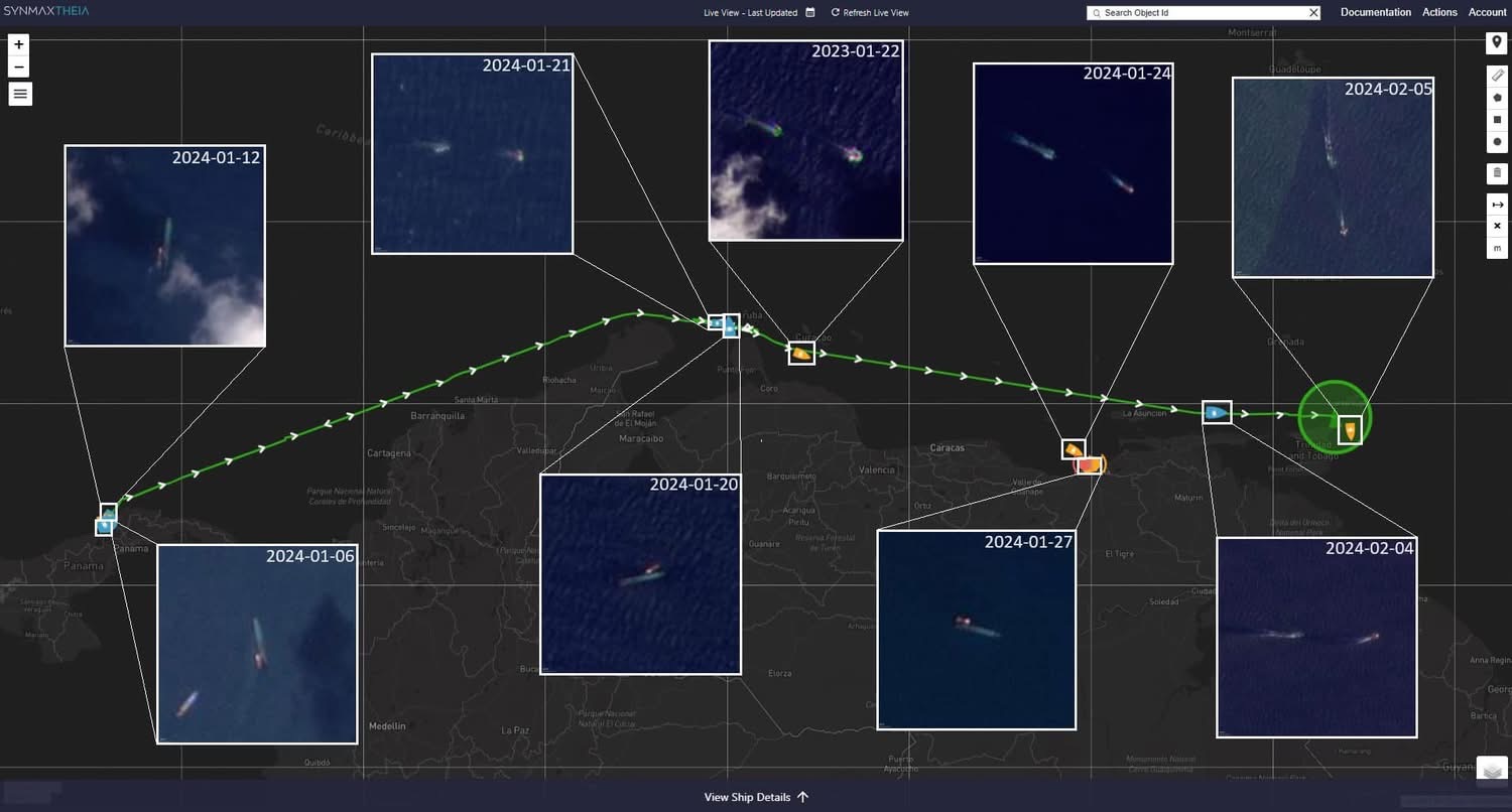
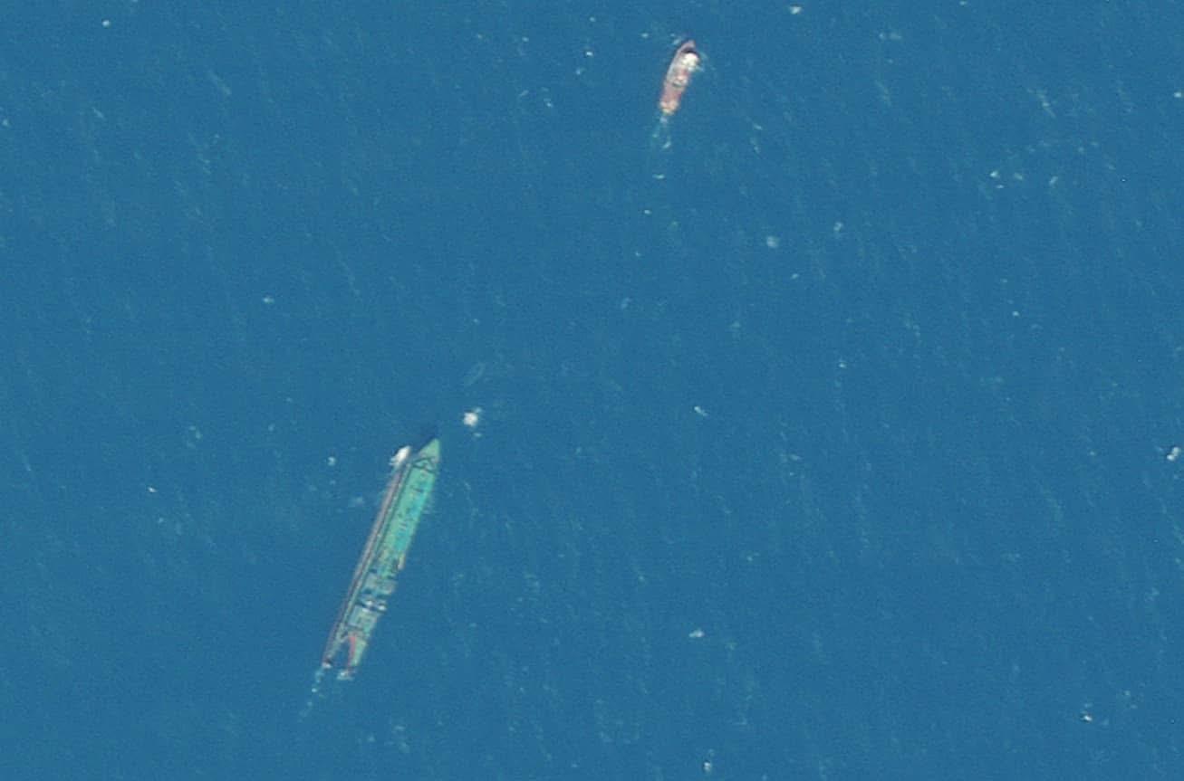
Evidence note: these images are reproduced from the owner-supplied contemporaneous reporting record. Labels and route lines are annotations; each claim is tested against the separate source record.
Reporting sequence
Updated 2 October 2026 with interactive graphics and linked documentation. Original publication date retained.
For about thirteen days before the Gulfstream capsized off Cove, the tug towing it stopped broadcasting its position. That is the central fact in the voyage, and it comes from the people who watched it happen.[1]
This weekend I contacted TankerTrackers.com, the firm that monitors oil shipments by satellite and transponder data, and asked them to take me through what they had seen. I asked about the dark period, about Pozuelo Bay, about the cargo, about the plausibility of different end uses, and about the history of the vessel identity attached to IMO 7505994. What follows is what they told me, attributed to them, alongside what remains unconfirmed.[1]
The distinction is deliberate. The satellite frames are observations. The AIS gap is an absence in a broadcast record. The cargo analysis is a specialist assessment. The ownership and destination questions require documents. Treating all four as one category of proof would overstate the evidence.
The questions I put to TankerTrackers
I did not ask for a general view of the spill. I asked them to test the specific propositions emerging from the vessel record:
1. For how long was the tug's AIS signal absent while it was north of Venezuela?
2. Had they observed the tug-and-barge combination in Pozuelo Bay, and for how long?
3. Did the quantity under discussion—about 35,000 barrels, or roughly 5,000 metric tonnes—look more like crude oil or heavy fuel oil in that setting?
4. Could that quantity have been loaded quickly from another vessel rather than through a conventional refinery shipment?
5. Were marine bunkering, ship-to-ship transfer or delivery to a power plant technically plausible uses for a cargo of that kind?
6. Had similar tug-and-barge combinations been observed in the bay during the same period?
7. What did the vessel history around IMO 7505994—Ranger, Margie V and Solo Creed—allow us to identify, and where did the databases conflict?[1][2][3]
Their answers did not arrive as a finished theory. I compared them with the satellite sequence I had published, the Ministry's naming of the tug, the physical characteristics of the barge and the public vessel records. That is how the separate clues became a testable account of the voyage.
The dark period
TankerTrackers told me the tug's Automatic Identification System was offline for about 13 days while it was north of Venezuela. A vessel that switches off AIS cannot be followed by the commercial tracking services that ports, insurers and coast guards rely on. It can still be seen from space, which is how the rest of the picture was assembled.[1]
The satellite sequence I published on 17 February placed the tug-and-barge combination on a track from Panama through Aruba and into Venezuelan waters before Tobago. The sequence supplied the missing geographic context: an Aruba call, subsequent observations along the Venezuelan coast, and an AIS gap during the same broad passage.6
I described that Venezuela stop at the time as covert because the tug was not broadcasting through the period being examined. The imagery supports the location sequence and the loss of the public AIS trail. It does not, by itself, establish why the signal stopped, what happened while the vessels were in Venezuelan waters, who directed the movement or whether concealment was intended. Those questions required the direct specialist-source testing set out below.[1]6
Pozuelo Bay
They said they had seen the vessel in Pozuelo Bay, on Venezuela's eastern coast, for about a week or more. The bay serves a refinery and terminal of Petróleos de Venezuela. They also said similar tug-and-barge combinations had been seen there recently. The Gulfstream was not unusual in that setting.[1]
That observation is material because it places the unit at an oil-handling location during the missing public track. It does not prove that loading occurred there. Establishing a transfer would require terminal logs, a bill of lading, tank records, a second vessel record or direct testimony.
What the barge was carrying
I asked whether the cargo was more likely crude or heavy fuel oil. Their view was that heavy fuel oil was the more plausible reading in context. Crude sent as refinery feedstock moves in far larger volumes; a barge-load makes little sense for that purpose.[2]
I asked whether roughly 35,000 barrels, about 5,000 metric tonnes, was consistent with that kind of cargo, and how quickly it could be loaded. They said it was consistent, and that a quantity of that size could be loaded quickly from another vessel.[2]
I also asked whether the fuel could have been intended as bunker fuel for ships, for ship-to-ship transfer, or for power generation. These are recognised uses for heavy fuel oil in the region, and the answers did not rule any of them out. None of them is established for this voyage. The Government has not yet said what the leaking substance is.[2]
The quantity is therefore a constraint, not a conclusion. It helps test whether a proposed use is commercially plausible; it cannot identify a buyer or destination. A technically plausible explanation remains a hypothesis until the transaction record supports it.
The identity trail
The tug has been named by the Ministry of National Security as the Solo Creed. The number attached to it in vessel records, IMO 7505994, carries a history. Earlier entries link it to the names Ranger and Margie V. Vessel databases contain historical records for these names that are confusing and in places overlap, so a name on its own proves little. That is why the IMO number, the hull, and the pairing of tug and barge matter more than any single label.[3]
The barge presented a different problem. As an unpowered unit it did not carry the kind of IMO identity expected on a self-propelled ship. The investigation therefore had to work outward from the physical Gulfstream name and hull, to the tug seen with it, and then to the tug's stable number. That is a chain of identification, not a database-name search.5
'Over 350 vessels named Gulfstream'
The Minister of Energy, Stuart Young, has said that more than 350 vessels carry the name Gulfstream, as an explanation for why identification has been slow.4 The name is common. The vessel is not. The barge at Cove can be tested against its hull characteristics, its relationship with a specific tug, the IMO history of that tug, satellite imagery of the two moving together, and other vessel records. Those tests narrow the field to one combination. Bellingcat had already done much of this work by 14 February.5
What remains provisional
Where the tow was going is not established. The official account says Guyana. Other routes and transfer points are being examined by people tracking the voyage, including me. Any destination theory is a hypothesis until there is documentary evidence: a charter, a bill of lading, a port record, or a statement from someone who can be held to it.
Corroboration and limits
The public imagery and the direct-source account corroborate the vessel's presence in Venezuelan waters. They do not independently corroborate the reason for the AIS gap or the cargo's intended end use. No formal response from the vessel interests is available in this reporting file, and their identities are not established on the evidence currently in hand.
The questions for the State
Has the Government asked Venezuela for loading records from Pozuelo Bay? Has it asked the flag state of the Solo Creed for the tug's registration and ownership? Where is the tug now? Why did the official account of the voyage not mention the dark period, when specialist trackers had documented it?
There is also an evidentiary question for the response agencies: what data did they possess, and when? A complete account should identify when the barge was first observed, when the tug was named, when the AIS gap was obtained, what requests were sent to foreign authorities, and whether cargo and registration records were preserved before they could disappear.
Those are not substitutes for evidence of wrongdoing. They are the minimum record needed to explain how an unidentified tow crossed the southern Caribbean, lost a fuel-laden barge off Tobago and left the public carrying the immediate cost.
Citations & source document
- [1]Direct correspondence with TankerTrackers.com, 18 February 2024Robinson's direct questions to TankerTrackers.comAIS offline about 13 days; vessel in Pozuelo Bay about a week or more; similar tug/barge units seen there. Screenshots retained by the publisher.
- [2]Direct correspondence with TankerTrackers.com, 18 February 2024Fuel assessmentHeavy fuel oil more plausible than crude; ~35,000 bbl / ~5,000 MT loadable quickly from another vessel.
- [3]Vessel identity trail around IMO 7505994Vessel identityRanger / Margie V / Solo Creed; overlapping historical database entries.
- [4]Trinidad and Tobago Guardian — Young: over 350 vessels named GulfstreamVessel identityThe Minister's explanation.
- [5]Bellingcat — Identifying the mystery vessel, 14 February 2024Satellite and open-source materialBarge identification.
- [6]Pearce Robinson — satellite sequence and Venezuela stop, 17 February 2024Panama, Aruba and the Venezuela stopContemporaneous publication of the Panama–Aruba–Venezuela–Tobago satellite sequence.
Every document cited above is held on this site, with the key clauses, extracts and findings set out in full and a link to the document of record.
Cite this article
Outlets, researchers and broadcasters may quote this reporting with credit and a link to the original.
Robinson, P. (18 February 2024). "Thirteen days dark: what TankerTrackers told me about the tug, the bay and the cargo". PearceRobinson.com. https://pearcerobinson.com/reporting/tobago-oil-spill-13-days-dark-2024
Independent reporting by Pearce Robinson. Corrections and responses may be submitted here.